Geopark Shetland has UNESCO Global Geopark status recognising the rich and varied earth heritage spanning almost three billion years. The geology is dramatic, diverse, and beautiful and still influences life in the islands today.

Shetland's unique geology

With rocks of every era from the Precambrian to the Carboniferous, Shetland’s geology is more diverse than any similar sized area in Europe.

Where else can you walk on ancient oceanic crust, explore an extinct volcano and stroll across shifting sands in the space of a day?

Step back millions of years

Over the past 700 million years, Shetland has travelled from a location close to the South Pole across the Equator to its current latitude of 60° north. On the journey, it experienced oceans opening and closing, mountains forming and eroding, tropical seas, volcanoes, deserts, ice ages and ancient rivers. Evidence of these earth-shaking events can be found throughout the isles including many unique – and spectacularly beautiful – geological features.

Geopark Shetland celebrates this incredible earth heritage and brings to life the fascinating stories behind Shetland’s geology and geographical location. Exploring the islands you'll discover how this influences every aspect of life in the isles, from the landscape and biodiversity to the settlement patterns and economy including Shetland's thriving fisheries to the productive clean energy sector and even the burgeoning space industry.

Begin your geological journey at the Museum and Archives in Lerwick, where displays tell Shetland’s story from its geological beginnings to the present day. From here, follow our self-guided trails below and discover stunning geological sites and fascinating aspects of Shetland’s heritage.

Exploring Geopark Shetland

We've compiled a list of places you can visit to discover more about the history of Shetland’s magnificent foundations. Please note, all directions are given as if driving from Lerwick.

  • Ronas Hill

    If you’re ready for a good hike climb to Shetland’s highest point (450m) – a broad dome of stony granite tundra. Features found at the top of Ronas Hill are typical of an Arctic environment – the granite was shattered by the constant freezing and thawing of water.

    Access is from Collafirth Hill. Descend by the same route.

    Duration: 4 hour walk

    Terrain: Rough ground, moderate climb and steep in places

    Getting there: Take the A970 north past Brae and Mavis Grind to Northmavine. Head north through Northmavine. Take a right, following signs to Collafirth and North Roe. Park at the masts at the top of Collafirth Hill — look out for unmarked track road off to left about 6 miles (9.5km) from the junction, before the pier and small marina.

    Eshaness

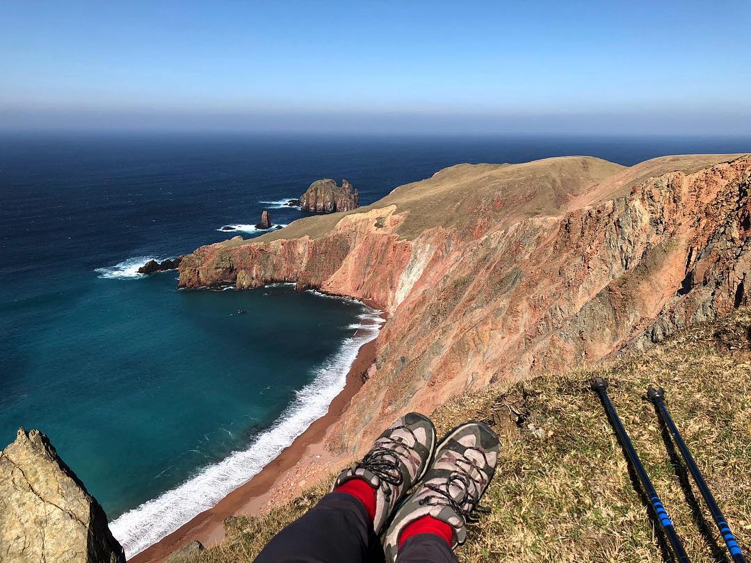
    Around 350 to 400 million years ago Eshaness was a barren desert that volcanoes erupted on to. Today Eshaness offers Shetland’s most dramatic coastal scenery and is the best section through the flank of a volcano in Britain. Ice ages and the relentless power of the ocean have since shaped this spectacular landscape. Look out for signs of lava and volcanic bombs as you go.

    Start your walk at Eshaness Lighthouse, and head north along the coast. Routes are marked on a panel next to the car park. For more information, explore the Northmavine Volcano Trail.

    Duration: 2-4 hour walk

    Terrain: Moderate ground and stiles to cross

    Getting there: Take the A970 north past Brae and Mavis Grind to Northmavine. Follow signposts to Hillswick (A970). At Hillswick turn right towards Eshaness (B9078). After 5 miles (8km) take the junction signposted ‘Lighthouse’, and park at end of road.

    Back o Ollaberry

    To explore enormous earth movements that happened 100 to 160 million years ago, head to the beach at the Back o Ollaberry. Walk over a massive fault line, part of the Great Glen Fault, that stretches as far as the west coast of Scotland. The rocks on one side of the fault have slid more than 100km past those on the other side.

    Walk around the churchyard then follow coastline until you reach an interpretive panel. From the panel, follow the coast until you reach a track road, which leads back to church.

    Duration: 1 hour walk

    Terrain: Moderate ground and stiles to cross

    Getting there: Take the A970 north past Brae and Mavis Grind to Northmavine. Head north through Northmavine and take a right to Ollaberry (B9079). Drive through Ollaberry. Turn right at post office, then an immediate left to church. Park next to church and churchyard.

  • Wormadale

    If you’re heading west, stop and enjoy the stunning view of voes and small islands at Wormadale. You are, in fact, looking at a flood. Thousands of years of rain has created the valleys and rounded hills here at Weisdale. Under the water is a vast landscape last exposed 10,000 years ago, before sea levels rose at the end of the last glaciation. Rainwater has slowly dissolved bands of soft limestone, leaving more resistant rocks standing in high ridges.

    Duration: 10 minute visit

    Getting there: Take the A970 north out of Lerwick. At Tingwall, take the A971 signposted to Walls and Sandness. There’s a parking area and viewpoint approximately 2 miles (3 km) from the junction.

  • Funzie

    At Funzie beach on the island of Fetlar you will discover ancient cobbles set into the cliffs which were squashed and stretched under immense heat and pressure 400 million years ago. The cobbles were squashed when a section of ocean crust was thrust upwards over continental rocks.

    Duration: 30 minute visit

    Terrain: Stony beach

    Getting there: Take the A970 north. At Voe turn right onto the A968 to Toft. Take the Yell ferry from Toft to Ulsta ferry terminal and then the A968 to Gutcher. Then take the Bluemull Sound ferry from Gutcher to Hamars Ness. Follow the B9088 to Funzie, and park at the end of the road next to beach.

    Gloup Voe

    The valley at the narrow sea inlet of Gloup Voe in Yell was carved 10,000 years ago by a huge river of melt-water flowing underneath the glacier. When you look at the narrow voe it’s surreal to think the melt-water alone formed the valley; you can only imagine how immense the ice sheet was.

    For the best views, walk from the memorial to the head of the voe.

    Duration: 1 hour walk

    Terrain: Moderate ground

    Getting there: Take the A970 north. At Voe turn right onto the A968 to Toft. Take the Yell ferry from Toft to Ulsta ferry terminal. Follow the A968 to Gutcher. Turn left onto B9083, signposted to Gloup Fisherman’s Memorial. At Gloup, turn right to Kirks, park at the Fisherman’s Memorial.

    Hagdale Chromite Quarry

    Shetland’s most northerly island Unst is made from a section of ocean floor. When continents collided 430 to 500 million years ago slices of ocean floor were thrust up above sea level, and minerals like chromite became exposed. Hagdale was once the biggest chromite quarry in the country and is also home to the only surviving horse-driven crushing circle.

    To view the quarry, walk down to the bottom of the track road.

    Duration: 1 hour visit

    Terrain: Uneven ground, moderate slope in places

    Getting there: Take the A970 north. At Voe turn right onto the A968 to Toft. Take the Yell ferry from Toft to Ulsta ferry terminal and then the A968 to Gutcher. Take the Bluemull Sound ferry from Gutcher to Belmont. From Belmont follow signs for Baltasound and Haroldswick. After Baltasound, go past Littlehamar junction and take the first right after the garage (signposted to Hagdale Horse Mill). Park at the gate.

  • St Ninian’s Isle

    The beach at St Ninian’s Isle is not to be missed. This spectacular sand tombolo is the best of its kind in Britain. We’re not going to say any more; go and see for yourself!

    Duration: 1 hour visit

    Terrain: Sandy beach

    Getting there: Head south on the A970, turn off right on to the B9122 towards Bigton. Follow signs to St Ninian’s Isle, a single-track road leads to a car park at the beach.